
Nyika National Park Guide
Discover Malawi’s Nyika Plateau with a detailed map, Chelinda bases, highland wildlife, birding, walking, seasons and practical road-trip planning.
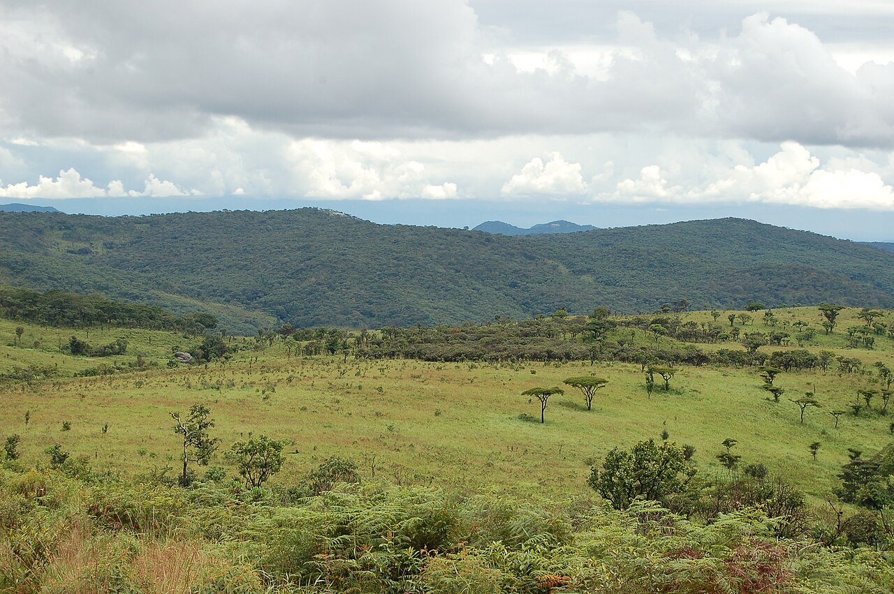
Grassland and wooded hills in Nyika National Park, Malawi. Photo: Joachim Huber from Switzerland · CC BY-SA 2.0. Resized and cropped for this layout.
.jpg)
Nyika National Park at a glance
Nyika changes the pace and temperature of a Malawi journey. Rolling highland grasslands stretch toward cloud, antelope graze on open slopes and pockets of forest shelter a different bird community. The plateau suits visitors who enjoy landscapes, quieter wildlife watching and time outside a conventional vehicle safari, through properly arranged walks or cycling. This guide focuses on Malawi’s national park and the Chelinda area. The adjoining Zambian park has separate administrative and border arrangements.
Official sources · checked 8 September 2026: Peace Parks: Nyika management and landscape · Malawi Tourism: Nyika visitor overview. Confirm arrangements for your travel date.
When is the best time to visit Nyika?
May–October is often a practical first-visit period for firmer roads and clearer access, with cold mornings during the cooler middle months. The plateau can still be windy, misty or wet, so a dry-season label is not a reason to leave warm clothing behind. The rainy season brings fresh grass, flowers and a different birding emphasis. Visitors particularly interested in orchids or green landscapes may prefer a wet-season visit, provided accommodation and transport can accommodate the conditions. November–April requires more flexibility on unsealed roads. A day that starts in mist can improve later; keep a local activity available rather than committing every morning to a distant viewpoint. Ask for a recent report on the entire approach, not just the weather at Chelinda.
Typical seasonal pattern, not a forecast or a guarantee of road access. Current local conditions take priority.
Which Nyika area suits your trip?
| Area | Best for | What to expect | Planning point |
|---|---|---|---|
| Chelinda and nearby grassland | A first plateau base | Accommodation, open slopes and nearby water features allow a varied stay without moving camp daily. | Confirm the booked property’s facilities and activity programme. |
| Chelinda dams | A quieter local outing | Water and damp grassland add birding interest to the surrounding plateau. | Map centres are geographic references, not permission to fish, swim or launch a boat. |
| Lake Kaulime and western plateau | A landscape-focused drive | Open country, forest pockets and a small highland lake provide a change from camp surroundings. | Use the current approved circuit and treat the lake’s cultural context respectfully. |
| Chosi, Domwe and northern uplands | Longer views and a more extensive outing | Viewpoints and hill country illustrate the plateau’s scale. | Allow time for weather, navigation and the return; a summit pin is not a marked public trail. |
| Fingira and southern approach | A separately planned cultural and landscape stop | The southern plateau includes rock formations and heritage interest. | Ask about authorised access and interpretation rather than entering a shelter independently. |
| Lower slopes and regional onward routes | A different habitat and travel context | Woodland and the descent toward northern Malawi change the character of the journey. | Do not mistake nearby Livingstonia or lakeshore pins for quick drives across the escarpment. |
Nyika entry fees, permits and opening hours
A complete current entry-and-vehicle tariff was not clearly available from the official public material reviewed. Ask DNPW or the responsible park booking team for the rate applicable to your nationality or residency, children, vehicle and overnight stay. Request a separate accommodation, camping, guide and activity breakdown. Clarify whether transfers, meals, equipment and conservation charges are included. A price for Chelinda accommodation alone should not be assumed to cover all park costs.
Official sources · checked 8 September 2026: Malawi Tourism: Nyika visitor overview · Malawi Tourism: Chelinda Lodge visitor listing. Confirm arrangements for your travel date.
Opening hours
Confirm gate opening, latest arrival and activity reporting times with the park and your booked accommodation. Arrive in daylight with enough margin for the unsealed approach. Night activities, if offered, require a specific authorised booking.
Official sources · checked 8 September 2026: Peace Parks: Nyika management and landscape · Malawi Tourism: Nyika visitor overview. Confirm arrangements for your travel date.
How do you get to Nyika?
Mzuzu and Rumphi are important staging points for road travel toward Nyika. Many Malawi-side visitors approach through Thazima before continuing up to the plateau and Chelinda. The final unsealed section can be slow and its condition changes, so get current directions and a recent road report from the park or camp. A suitable 4×4, good tyres and a sensible fuel reserve are prudent. Buy supplies before the remote approach and keep essential booking details offline. Chelinda airfield can support arranged fly-in access when available; confirm the flight, strip condition and camp transfer rather than assuming a published airfield symbol means scheduled service. Cross-border approaches and the Zambian side require their own permissions. Avoid planning a tightly timed onward flight after the descent.
Official sources · checked 8 September 2026: Peace Parks: Nyika management and landscape · Malawi Tourism: Nyika visitor overview. Confirm arrangements for your travel date.
Nyika safari map: 20 useful places
Use this map to compare bases and understand the landscape. Search by place or filter by type. All locations are approximate orientation points; current park, guide and lodge directions override the map.
Loading map near this section. All places are also listed below.
All 20 map places and access notes
- Thazima entrance · Gates & visitor centresMain Malawi-side approach reference. Confirm current road and gate arrangements. Map source. Approximate.
- Thazima park office · Gates & visitor centresVisitor-administration reference; seek the current approved route and reporting instructions. Map source. Approximate.
- Chelinda park office · Gates & visitor centresLocal visitor-information reference. Arrange activities and confirm open circuits. Map source. Approximate.
- Chelinda Lodge · Camps & lodgesMain plateau accommodation reference; confirm operation, meals and activities. Map source. Approximate.
- Chelinda Camp · Camps & lodgesMapped as Celinda Camp. Verify the exact booked accommodation and facilities. Map source. Approximate.
- Chelinda campsite · Camps & lodgesConfirm camping reservation, cold-weather equipment and available facilities. Map source. Approximate.
- Chelinda airfield · AirstripsArranged aviation reference; flight, strip condition and transfer require confirmation. Map source. Approximate.
- Chelinda Dam 2 · Water featuresWaterbody-centre orientation point. Fishing or other use needs current permission. Map source. Approximate.
- Chelinda Dam 1 · Water featuresLocal landscape and birding reference, not a swimming or launch location. Map source. Approximate.
- Chelinda Dam 3 · Water featuresConfirm the authorised visitor circuit; do not navigate directly across wet grassland. Map source. Approximate.
- Lake Kaulime · Water featuresHighland lake and cultural landscape reference. Follow authorised access and local guidance. Map source. Approximate.
- Chosi viewpoint · ViewpointsLandscape stop on an appropriately planned plateau outing; visibility varies. Map source. Approximate.
- Domwe viewpoint · ViewpointsNorthern landscape reference requiring a realistic return margin. Map source. Approximate.
- Western plateau viewpoint · ViewpointsUnnamed mapped viewpoint; confirm local route and access before including it in a drive. Map source. Approximate.
- Fingira Rock · ViewpointsHeritage and landscape reference. Arrange the authorised approach and interpretation. Map source. Approximate.
- Jalawe uplands · ViewpointsGeographic reference in the northern plateau; no marked trail or visitor access is implied. Map source. Approximate.
- Vitinthiza Hill · ViewpointsWestern plateau orientation; use approved routes rather than a direct line to the hill. Map source. Approximate.
- Kaperekezi Gate · Gates & visitor centresAlternative access near the border; confirm operation and any immigration requirements. Map source. Approximate.
- Zambian Guest House — border context · Camps & lodgesSeparate Zambian-side reference. Confirm border formalities, legal access and current accommodation operation. Map source. Approximate.
- Mwanda Peak — southern landscape · ViewpointsRegional hill reference, not a validated trekking destination. Map source. Approximate.
Map references include official park material where specified below, plus OpenStreetMap contributors, checked 8 September 2026. Selected and labelled by See.Africa. Waterbody-centre pins and summits are geographic references, not destinations for direct navigation. Accommodation and airstrip operation must be confirmed. No live animal locations or verified driving route is shown.
A practical Nyika itinerary
Day 1: arrive without rushing
Allow the transfer to take the time it needs. Settle at Chelinda, confirm the next day’s activities and enjoy a short local outing if conditions allow. Look for grazing antelope and learn the shape of the surrounding slopes before attempting a longer circuit.
Day 2: plateau wildlife and water
Use the morning for a slow grassland drive with plenty of stops for roan, eland and zebra. Add an approved local water feature or viewpoint later. Weather can change the light quickly, so keep the plan flexible and carry layers even on a short excursion.
Day 3: choose a specialist interest
Arrange a walk, mountain-bike outing, focused birding or a longer landscape drive according to the group’s interests. Flowers and forest birds need time at a different pace from a mammal-focused drive. A misty morning is a good reason to stay local, not to race to the highest point.
Day 4: leave room for the road
Take a short early outing only if it fits the departure plan. Refuel and rest at a suitable staging town before continuing farther. Pair Nyika with a northern lakeshore stay for a strong landscape contrast, but allocate a proper transfer rather than treating the descent as a brief scenic hop. Couples building a honeymoon around the lake will find lodge rates and the best months in this Malawi honeymoon planning guide.
Where should you stay in Nyika?
Chelinda Lodge, Chelinda Camp and camping arrangements offer different levels of service around the main visitor area. Confirm the current operator, opening dates and what your booking actually supplies: meals, bedding, heating or fireplace arrangements, power, drinking water and activities. A highland cabin can be comfortable while the drive to reach it remains demanding. Camping requires suitable cold-weather sleeping equipment and an explicit understanding of facilities. For a first visit, staying several nights in one plateau base usually makes better use of time than repeatedly driving up from outside. The map includes selected regional references for orientation; they are not endorsements or live availability checks.
Nyika mammals to look for
Begin with the plateau’s large grazers. Roan and eland can make memorable groups against rolling grassland, while zebra and bushbuck give other chances to observe feeding and alert behaviour. Cats and hyenas are much less predictable. Elephants occur in the wider park, especially lower areas, and should not be expected routinely on the open Chelinda plateau. Species profiles cover a range of habitats and encounter probabilities.

Roan antelope
Large ears with dark tips, a pale reddish coat and a boldly marked face distinguish this substantial antelope. It can be local and elusive. Watch grassy woodland quietly and avoid turning the presence of suitable habitat into a promise that a herd will appear.
_Mlilwane.jpg)

Common eland
Africa’s largest antelope has a deep body, a dewlap and gently spiralling horns. Its size does not prevent it from moving gracefully through open woodland. Watch mixed-age groups at a respectful distance and distinguish it from buffalo by its lighter build and horn shape.


Plains zebra
Look beyond the stripes: herd spacing, ears and alarm behaviour can tell you what is happening in a grassland. Foals may rest while adults stand watch. Scan the edges of a herd for predators without losing sight of the zebras’ own social interactions.


Southern reedbuck
A sandy-brown antelope associated with grassland and damp ground. Males carry curved horns, while the pale throat and dark bare patch below the ear can help at closer viewing distances. Scan taller grass patiently: a resting animal may remain hidden until it lifts its head.
_iSimangaliso_Wetland_Park,_KwaZulu-Natal,_South_Africa.jpg)

Bushbuck
A medium-sized antelope that favours cover rather than open herds. Coat colour, striping and spotting vary across its range. Watch forest edges and quiet paths at first or last light; often only an ear or a brief movement betrays its presence.
.jpg)

Common warthog
Facial pads, curved tusks and a tail held upright when running make identification straightforward. Warthogs often kneel on their front legs to feed. Give burrow entrances space, and do not approach a family because the piglets appear small or playful.
,_parque_nacional_del_Lago_Mburo,_Uganda,_2024-02-01,_DD_26.jpg)

Leopard
Rosettes, a long tail and a powerful, low body distinguish this secretive cat. Search riverine trees, shaded rocks and dense drainage lines. A leopard can disappear in apparently thin cover; patient scanning is more useful than assuming that a radio report guarantees a sighting.
.jpg)

Spotted hyena
Sloping shoulders and rounded ears help separate it from other large carnivores. This is an effective hunter as well as a scavenger. Animals travelling at dawn, resting near drainage lines or calling after dark reveal a social life easily missed on a hurried drive.
.jpg)

Serval
Long legs and oversized ears suit a cat that hunts small prey in grassland and marsh edges. It is an uncommon, often fleeting sighting. Watch for deliberate listening and sudden pounces, and resist the temptation to drive into grass for a better view.


African bush elephant
The broad ears, curved tusks and long trunk are unmistakable. Watch how a family spreads out to feed, then regroups before moving. Stop well back from the herd and leave its crossing route open; a close calf is a reason to retreat, not advance.

Nyika birds and habitat clues
Highland grassland and sheltered forest pockets are the two main birding themes. Wattled cranes and Denham’s bustard are notable open-country targets; blue swallow is associated with suitable montane grassland and seasonal conditions. Forest trogons need a patient, habitat-specific outing, while damp places can support smaller waterside birds. These are targets to discuss with a local guide, not a promise that every species occurs around your room. No nesting locations are mapped.

Wattled crane
A very tall crane with a pale neck, grey body and hanging throat wattles. Wet grassland and marsh edges are the key habitats. Watch with binoculars from an existing route; approaching a feeding or breeding pair can disrupt birds using a limited patch of suitable ground.


Denham’s bustard
A substantial grassland bird with a long neck and patterned upperparts. In flight, the bold wing pattern is a useful clue, but birds should never be flushed to obtain it. Scan slopes and longer grass slowly, especially where a distant head can appear before the body becomes visible.
_(7083219537).jpg)

Blue swallow
Glossy dark blue plumage and a long forked tail distinguish adults in good light. This threatened swallow feeds over suitable moist montane grassland, often moving too quickly for an easy first identification. Watch from an established route and avoid inspecting ground cavities that could be breeding sites.


Augur buzzard
A broad-winged raptor often watched above highland grassland and rocky slopes. Pale adults have strongly contrasting dark upperparts and a reddish tail; darker forms occur too. Compare wing pattern and flight with nearby eagles rather than estimating size against an empty sky.
.jpg)

Long-crested eagle
The tall crest gives a perched bird a distinctive outline. It often watches grassy openings from a tree or post, with conspicuous pale wing patches visible in flight. Patiently observing a chosen perch can be more productive than driving quickly between distant raptor shapes.
_3.jpg)

Bar-tailed trogon
A quiet forest bird that can sit still for long periods on a shaded branch. Bright underparts are often hidden by leaves. Once located, use binoculars and wait for a natural turn instead of moving off the trail to expose the bird.


Narina trogon
The male’s metallic green upperparts and red belly are striking, yet a stationary bird can be very hard to spot. Listen first and search horizontal branches in suitable woodland. Keep any viewing session quiet and brief when a bird appears unsettled.
.jpg)

Malachite kingfisher
A tiny blue-and-orange bird that favours low perches beside water. It can disappear against reflections despite its bright colours. Scan patiently along reed edges with binoculars and remain on the permitted path or in the boat.
.jpg)
Nyika plants and habitats
Montane grassland
Rolling grass-covered slopes are a defining feature. Grazing, moisture and season create patches of different height and colour; watch how antelope distribute themselves across them.
Orchids and wildflowers
Nyika is celebrated for its floral diversity, particularly during the rains. A specialist guide and close observation reveal far more than walking quickly past the same patch. Photograph plants in place and avoid trampling surrounding growth.
Evergreen forest islands
Sheltered forest patches interrupt the open plateau and hold a different microclimate. Their edges are useful places to listen for birds before entering on an approved route.
Damp grassland and streams
The plateau is an important water catchment. Wet hollows can remain soft even in otherwise dry weather; avoid creating new paths around muddy ground.
Plantations and visitor landscapes
Not every stand of tall trees around a visitor base is native forest. Distinguishing planted areas from indigenous patches helps make sense of the park’s habitat story.
Plant identification may require leaves, flowers, fruit and a knowledgeable guide. Do not collect plants or leave authorised routes to inspect them.
What can you do in Nyika?
Follow the antelope rhythm
Watch a herd for longer than a quick photograph. Grazing, resting and vigilance can be especially easy to read against the open slopes.
Arrange a plateau walk
An authorised walk gives time for plants, tracks and smaller details. Match distance, weather and guiding arrangements to the group rather than choosing a distant hill only because it is mapped.
Try mountain biking when available
Confirm equipment, route, guide requirements and recovery arrangements. Wind, altitude and uneven ground can make a short-looking outing more demanding than expected.
Make a bird-and-flower day
A specialist focus changes the pace of the safari and is especially rewarding in the right season. Keep to approved routes and leave breeding birds and delicate vegetation undisturbed.
Rules and practical precautions
Use authorised routes and current park guidance for walks, cycling and heritage sites. Do not collect flowers, enter nesting cavities or disturb cranes and other grassland birds. Secure food at camp and supervise children around wildlife. Respect the international boundary and obtain separate permission for any cross-border route.
Give wildlife space
Never feed, surround or block an animal. Keep food secure, voices low and movements predictable. Your guide or ranger’s instructions take priority over a desired photograph.
Prepare for your actual activity
Bring water, sun or rain protection as appropriate, suitable footwear and charged equipment. Tell the operator about relevant mobility needs before booking so the route and vehicle can be matched to you.
Official sources · checked 8 September 2026: Peace Parks: Nyika management and landscape · Malawi Tourism: Nyika visitor overview. Confirm arrangements for your travel date.
Nyika travel FAQ
Where is Nyika National Park?
Malawi’s Nyika National Park protects much of the high Nyika Plateau in northern Malawi. This guide focuses on the Malawi side and the Chelinda visitor area.
How many nights are enough?
Three nights is a useful first visit, giving two full days and flexibility for weather and a slow approach road.
What animals is Nyika known for?
Roan, eland, zebra and other antelope are central to the plateau experience. Leopard is elusive, and elephants are more associated with lower parts of the wider park.
Is the rainy season worth considering?
Yes, especially for green scenery, flowers and particular birding interests, but road conditions and accommodation operation need careful confirmation.
Can I drive to Chelinda in an ordinary car?
Do not assume the unsealed approach will suit one. Obtain a recent road report; a suitable 4×4 is a prudent choice for a remote plateau visit.
Are Nyika fees published here?
No verified complete current tariff was available in the official material checked. Request an itemised entry, vehicle, accommodation and activity quote before travel.
Sources, method and review date
This guide combines official park and operator information with editorial planning advice. Operational details were checked on 8 September 2026. Season descriptions are typical patterns, and suggested stays are planning recommendations. Wildlife profiles explain identification and habitat; they do not promise sightings.
Wildlife and image references
Species names and identification photographs were checked against the linked reference and image records. Photographs are identification examples and may have been taken elsewhere. Each image carries its own creator and licence credit.
Species reference links
Roan antelope · Common eland · Plains zebra · Southern reedbuck · Bushbuck · Common warthog · Leopard · Spotted hyena · Serval · African bush elephant · Wattled crane · Denham’s bustard · Blue swallow · Augur buzzard · Long-crested eagle · Bar-tailed trogon · Narina trogon · Malachite kingfisher