
Table Mountain National Park Guide
Explore Table Mountain National Park with a detailed map, Cape Point, Boulders penguins, hiking decisions, section-by-section fees, wildlife and Cape Town planning.
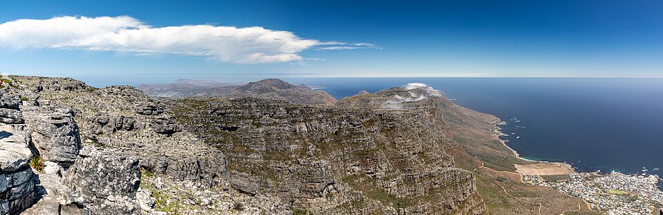
Mountain plateau and Atlantic coast viewed from Table Mountain. Photo: Dietmar Rabich · CC BY-SA 4.0. Resized and cropped for this layout.
,_Table_Mountain_--_2024_--_2794%2B96%2B98%2B2800%2B01.jpg)
Table Mountain National Park at a glance
Table Mountain National Park stretches across a remarkably varied Cape Peninsula landscape. The famous summit is only one part: Cape Point, the Cape of Good Hope, Boulders, Silvermine and forested slopes offer different outings with separate practical arrangements. Plan around weather and geography instead of trying to combine everything in a single day. A clear summit opportunity may be best used immediately, while penguins or a shorter low-level walk can suit another day. The park is close to a major city, but exposed paths, steep ground and rapidly changing mountain weather still require proper preparation.
Official sources · checked 9 September 2026: SANParks: Table Mountain National Park overview · SANParks: current visitor notices. Confirm arrangements for your travel date.
When is the best time to visit Table Mountain?
Summer often brings longer dry periods but also strong wind and heat. Winter can bring rain, slippery rock, low cloud and short windows for a high-level outing. Spring and autumn can offer pleasant walking conditions, but the forecast for the actual route matters more than the month. Cloud can form rapidly over the mountain, reducing visibility and temperature even after a warm start in the city. Keep a flexible itinerary: use a suitable clear period for the summit and schedule another section when mountain conditions are poor. Carry warm and waterproof layers, water and sun protection. If the cableway is central to the plan, check the operator’s live status before leaving and again before committing to a dependent connection.
Typical seasonal pattern, not a forecast or a guarantee of road access. Current local conditions take priority.
Which Table Mountain area suits your trip?
| Area | Best for | What to expect | Planning point |
|---|---|---|---|
| Table Mountain summit and City Bowl slopes | Mountain views and a carefully selected hike | Cableway access and walking routes involve different levels of effort and exposure. | Check live cableway operation, route conditions and a realistic descent plan. |
| Cape Point and Cape of Good Hope | A full peninsula landscape outing | Cliffs, fynbos, beaches and antelope make this more than a lighthouse photograph. | Pay the relevant section fee and allow the drive back to the entrance before closure. |
| Boulders | Managed African penguin viewing | Boardwalks provide a defined visitor experience close to a breeding colony. | Follow the current access and beach rules and avoid crowding penguins. |
| Silvermine | A separate mountain and fynbos outing | Choose an authorised trail or visitor area suited to the weather and group. | Confirm the correct entrance, permit and seasonal closing time. |
| Newlands and Tokai areas | Forest-edge and lower-slope recreation | Different vegetation and established visitor routes provide alternatives to the summit. | Activities and access permissions differ between areas; use the current official guidance. |
| Atlantic coastal stops | Ocean views and permitted recreation | Oudekraal and other designated places show the coastal side of the park. | Check opening days, local sea conditions and the exact activity allowed. |
Table Mountain entry fees, permits and opening hours
These SANParks conservation fees apply to the named paid sections under the 1 November 2025–31 October 2026 tariff; the recreation-section rows show the fee for each section, not a combined pass. Adults are aged 12 and over and children 2–11. Cape Point and Boulders are cash-free; bring a payment card and the identification required for your visitor category. Claim the correct category before payment. Cableway, funicular and other operator charges are separate. Wild Card coverage depends on the membership and attraction; confirm before relying on it. Use the next tariff for travel from 1 November 2026.
| Visitor category / section | Adult | Child (2–11) |
|---|---|---|
| Boulders · SA citizens/residents | R55 | R26 |
| Boulders · SADC nationals | R110 | R55 |
| Boulders · other international visitors | R245 | R120 |
| Cape Point · SA citizens/residents | R110 | R55 |
| Cape Point · SADC nationals | R225 | R115 |
| Cape Point · other international visitors | R515 | R250 |
| Newlands / Oudekraal / Silvermine / Tokai picnic · SA | R44 | R22 |
| Same listed recreation sections · SADC | R90 | R45 |
| Same listed recreation sections · international | R200 | R100 |
Official sources · checked 9 September 2026: SANParks: current conservation fees · SANParks: current visitor notices. Confirm arrangements for your travel date.
Opening hours
Each visitor section has its own schedule. Cape Point is listed as 06:00–18:00 in October–March and 07:00–17:00 in April–September. Boulders is listed as 07:00–19:30 in December–January, 08:00–18:30 in February–March and October–November, and 08:00–17:00 in April–September. Cableway and funicular schedules are separate and weather-dependent operation can change a day’s plan. Check the official gate table for Silvermine, Newlands, Tokai and Oudekraal rather than extending Cape Point’s hours to the whole park.
Official sources · checked 9 September 2026: SANParks: current visitor notices · SANParks: entrance hours · SANParks: access and directions. Confirm arrangements for your travel date.
How do you get to Table Mountain?
Cape Town provides the main air gateway and accommodation base. Choose transport for the specific outing: the lower cable station, Boulders and Cape Point are different destinations with substantial travel between them. A booked peninsula excursion can simplify a coastal day, while a rental vehicle gives flexibility if you are comfortable with local driving and parking. Confirm return transport before a hike; a trail ending on another side of the mountain does not return you to the car. Kirstenbosch is a separately managed botanical garden, and its admission and any connecting hiking plan require separate consideration. Allow extra time for city traffic, popular parking areas and stops along the peninsula.
Official sources · checked 9 September 2026: SANParks: current visitor notices · SANParks: access and directions. Confirm arrangements for your travel date.
Table Mountain map: 30 useful places
Use this map to compare bases and understand the landscape. Search by place or filter by type. All locations are approximate orientation points; current park, guide and lodge directions override the map.
Loading map near this section. All places are also listed below.
All 30 map places and access notes
- Lower Cable Station · Gates & visitor centresCableway station. Transport tickets, live operating status and service hours are separate from general park arrangements. Do not rely on an operating cableway as your only hiking descent plan. Map source. Approximate.
- Upper Cable Station · Gates & visitor centresCableway station. Transport tickets, live operating status and service hours are separate from general park arrangements. Do not rely on an operating cableway as your only hiking descent plan. Map source. Approximate.
- Table Mountain (Maclear’s beacon) · Areas & trail referencesSummit geographic reference, not a trailhead. Use a suitable authorised route with proper weather, navigation and descent planning. Map source. Approximate.
- Kloof Corner · ViewpointsUse the designated viewpoint or hide only when open. Follow the current visitor route and keep clear of edges and wildlife. Map source. Approximate.
- Platteklip Visitor Information Centre · Gates & visitor centresVisitor access point. Confirm the correct entrance, current hours and onward directions before arrival. Map source. Approximate.
- Waterworks Museum · Gates & visitor centresVisitor access point. Confirm the correct entrance, current hours and onward directions before arrival. Map source. Approximate.
- Woodhead Reservoir · Gates & visitor centresVisitor access point. Confirm the correct entrance, current hours and onward directions before arrival. Map source. Approximate.
- Newlands Forrest Picnic Site · Areas & trail referencesLandscape or trail reference. This pin is not a trailhead or a verified route; obtain the current authorised map and advice. Map source. Approximate.
- Cecilia Waterfall · Areas & trail referencesLandscape or trail reference. This pin is not a trailhead or a verified route; obtain the current authorised map and advice. Map source. Approximate.
- Dam View · ViewpointsUse the designated viewpoint or hide only when open. Follow the current visitor route and keep clear of edges and wildlife. Map source. Approximate.
- Tokai View · ViewpointsUse the designated viewpoint or hide only when open. Follow the current visitor route and keep clear of edges and wildlife. Map source. Approximate.
- Noordhoek Lookout · ViewpointsUse the designated viewpoint or hide only when open. Follow the current visitor route and keep clear of edges and wildlife. Map source. Approximate.
- Boulders Visitor Centre · Gates & visitor centresManaged penguin visitor area. Pay the relevant admission, use designated access and keep clear of birds; do not touch, feed or obstruct them. Map source. Approximate.
- The Boulders · Areas & trail referencesManaged penguin visitor area. Pay the relevant admission, use designated access and keep clear of birds; do not touch, feed or obstruct them. Map source. Approximate.
- Buffelsfontein Visitors Centre · Gates & visitor centresVisitor access point. Confirm the correct entrance, current hours and onward directions before arrival. Map source. Approximate.
- Old Lighthouse · ViewpointsUse the designated viewpoint or hide only when open. Follow the current visitor route and keep clear of edges and wildlife. Map source. Approximate.
- Cape Point · ViewpointsUse the designated viewpoint or hide only when open. Follow the current visitor route and keep clear of edges and wildlife. Map source. Approximate.
- Cape of Good Hope · Areas & trail referencesLandscape or trail reference. This pin is not a trailhead or a verified route; obtain the current authorised map and advice. Map source. Approximate.
- Diaz Cross · Areas & trail referencesLandscape or trail reference. This pin is not a trailhead or a verified route; obtain the current authorised map and advice. Map source. Approximate.
- Da Gama Cross · Areas & trail referencesLandscape or trail reference. This pin is not a trailhead or a verified route; obtain the current authorised map and advice. Map source. Approximate.
- Peagrams Point · ViewpointsUse the designated viewpoint or hide only when open. Follow the current visitor route and keep clear of edges and wildlife. Map source. Approximate.
- False Bay lookout · ViewpointsUse the designated viewpoint or hide only when open. Follow the current visitor route and keep clear of edges and wildlife. Map source. Approximate.
- Smits Winkel Bay View site · ViewpointsUse the designated viewpoint or hide only when open. Follow the current visitor route and keep clear of edges and wildlife. Map source. Approximate.
- Smitswinkelbaai tented camp · Camps & lodgesAccommodation reference. Book ahead and obtain the correct reception, arrival route and current facilities from the operator. Map source. Approximate.
- Perdekloof · Areas & trail referencesLandscape or trail reference. This pin is not a trailhead or a verified route; obtain the current authorised map and advice. Map source. Approximate.
- Kirstenbosch Botanical Gardens — separate management · Areas & trail referencesSeparately managed botanical garden with its own admission and hours. Connecting mountain routes require a suitable hiking plan; this is a geographic reference rather than a specific entrance. Map source. Approximate.
- Chapman’s Peak Drive viewpoint — road-trip context · ViewpointsCoastal road viewpoint. Road opening and toll arrangements are separate from national-park conservation fees. Map source. Approximate.
- Cape Point / Cape of Good Hope entrance · Gates & visitor centresVisitor access point. Confirm the correct entrance, current hours and onward directions before arrival. Published facility coordinate; approximate orientation only. Map source. Approximate.
- Silvermine entrance area · Gates & visitor centresSilvermine entrance-area reference. Confirm Gate 1 or Gate 2 and current permissions for your chosen outing. Map source. Approximate.
- Slangkop tented-camp area · Camps & lodgesAccommodation reference. Book ahead and obtain the correct reception, arrival route and current facilities from the operator. Published facility coordinate; approximate orientation only. Map source. Approximate.
Map references include official park material where specified below, plus OpenStreetMap contributors, checked 9 September 2026. Selected and labelled by See.Africa. Waterbody-centre pins and summits are geographic references, not destinations for direct navigation. Accommodation and airstrip operation must be confirmed. No live animal locations or verified driving route is shown.
A practical Table Mountain itinerary
A first clear day: summit focus
Check the forecast and cableway status. Choose either a suitable guided hike or cableway outing with enough time to enjoy the summit paths safely. Keep an independent descent contingency and avoid adding a distant Cape Point visit to an already demanding walk.
One full day: southern peninsula
Start with enough time for Boulders and the Cape Point section, budgeting separately for both. Allow unhurried penguin viewing and choose a manageable scenic circuit in the southern park. Turn back well before the gate deadline.
Three or four days: flexible Cape Town base
Hold the summit outing for a suitable weather window. Give the southern peninsula its own day and add Silvermine, a forest route or an authorised coastal stop on another. This spreads driving and gives different habitats proper attention.
Poor mountain weather
Change the activity rather than assuming a lower cloud base will clear during the climb. Use an appropriate low-level attraction or an indoor city alternative. A cancelled summit day is preferable to committing to exposed terrain without visibility or a secure descent.
Where should you stay in Table Mountain?
Cape Town accommodation works well for several park outings, but choose the neighbourhood around your wider travel plans and transport. City Bowl and nearby areas simplify access to the main mountain; a southern peninsula base can reduce repeated journeys to Boulders and Cape Point. Park accommodation and trail overnight options have booking-specific access and supply requirements, so read the reservation carefully. Do not treat an accommodation pin as public parking or a route entrance. For a short visit, staying in one base and moving the day’s activity with the weather is usually simpler than changing hotels each night. Confirm early departures and late returns with your transport provider.
Table Mountain mammals to look for
Wildlife is spread across very different settings. Antelope are associated particularly with suitable southern-peninsula habitat, not a promise for the summit. Hyraxes may be more conspicuous around rocks, while caracal are elusive and should be observed without approaching. Keep food secured against baboons and follow local instructions without feeding or surrounding animals.

Rock hyrax
This small, rounded mammal may sun itself on rocks before retreating into a crevice. Look for sentries and listen for alarm calls. Hyraxes are mammals, despite their superficially rodent-like appearance; rocky picnic areas can offer good observation from an appropriate distance.


Chacma baboon
A long muzzle and substantial build identify this southern African baboon. Troops forage widely and readily investigate unsecured food. Keep doors, windows and picnic bags closed; never feed an animal or display food to attract it for a photograph.
_(16824823063).jpg)

Caracal
Long dark ear tufts and a plain tawny coat are the best clues to this secretive cat. It can remain hidden in low vegetation close to a road. An encounter is a bonus, not a routine expectation; give it space to continue moving naturally.
_(cropped).jpg)

Klipspringer
A compact antelope of rocky slopes, often seen in pairs. Its specialised hooves allow precise movement over boulders. Use binoculars to inspect rocky outcrops from the road and do not climb after it; the surrounding terrain may also conceal larger wildlife.
_male_Serengeti.jpg)

Grey rhebok
A woolly grey coat, long ears and a fine, upright posture suit a highland antelope that can blend into muted slopes. Males carry slender straight horns. Scan rocky grassland slowly; movement often reveals an animal before its outline becomes clear.
_male_at_Karoo_NP,_Western_Cape,_South_Africa.jpg)

Steenbok
A small reddish antelope with large ears and a pale underside. Individuals often stand still near low cover and can disappear after only a few steps. Stop gently and observe from the road instead of driving toward the spot where one hid.
.jpg)

Common eland
Africa’s largest antelope has a deep body, a dewlap and gently spiralling horns. Its size does not prevent it from moving gracefully through open woodland. Watch mixed-age groups at a respectful distance and distinguish it from buffalo by its lighter build and horn shape.


Red hartebeest
An elongated face, high shoulders and angular horns give this reddish antelope a distinctive silhouette. Compare its body shape with nearby wildebeest or blesbok. A standing lookout may reveal a group concealed in a fold of the grassland.


Bontebok
The white face, pale rump and rich brown body help identify this Cape antelope. Compare the pattern carefully with blesbok rather than relying on colour alone. Quiet grazing groups make rewarding subjects from permitted roads and paths.
_(30573334994).jpg)

Cape porcupine
Long black-and-white quills make a close view unmistakable, but this mainly nocturnal mammal is rarely obvious during an ordinary day visit. Notice feeding signs with a guide and keep a respectful distance. Never corner an animal or try to collect quills from it.

Table Mountain birds and habitat clues
The park combines internationally familiar penguins with birds closely tied to Cape vegetation. Watch flowering shrubs quietly for sunbirds and sugarbirds, then compare those communities with rocky-shore and marine birds. Boulders offers managed access to penguins; other coastal wildlife should be viewed from suitable public points without pursuing birds into resting or nesting areas.

African penguin
A black facial band and spotted white belly distinguish this endangered southern African penguin. At a managed colony, stay behind barriers and let birds cross paths naturally. Keep fingers, food and camera equipment away from the birds, and leave nesting areas undisturbed.
,_crop.jpg)

Cape sugarbird
A long curved bill and, in males, exceptionally long tail feathers make this fynbos specialist distinctive. Watch flowering proteas from the path. Patience often brings a bird back to a feeding perch without needing to enter fragile vegetation.
.jpg)

Orange-breasted sunbird
The male’s vivid breast and metallic head are easiest to appreciate in good light; females are much quieter in colour. Flowering fynbos is the right habitat to inspect. Pause beside an existing path and watch natural feeding movements between blooms.


Malachite sunbird
Breeding males have brilliant green plumage and a long tail; females and non-breeding birds require a more careful look. Flowering slopes can be productive. Avoid confusing a flash of green with a complete identification, particularly when several sunbirds share a patch.


Cape cormorant
A dark coastal cormorant often seen commuting in groups or resting on rocks. An orange-yellow throat patch helps at closer viewing distances. Several cormorant species share the coast, so use binoculars and compare structure as well as colour.


African oystercatcher
An all-dark body, bright red bill and pinkish legs make this coastal bird distinctive. Search rocky shores and suitable beaches from established paths. Nesting pairs and young are easily disturbed; give resting birds a generous berth and obey seasonal beach restrictions.
.JPG)

Verreaux’s eagle
A large dark eagle associated with rocky landscapes. Adults show a pale back marking and contrasting wing panels, although distance and strong backlight can hide them. Watch the shape and soaring pattern with binoculars. Cliff nesting birds should be observed from public routes without approaching ledges.
,_Aquila_verreauxii,_at_Walter_Sisulu_National_Botanical_Garden,_Gauteng,_South_Africa_(28825027073).jpg)

Jackal buzzard
This broad-winged southern African raptor often uses slopes and uplift. Adults can show rich chestnut on the chest and tail, though distance and light complicate identification. Study several features together and compare with other buzzards before naming a silhouette.


Cape bunting
A striped face, warm wing tones and seed-eating bill identify this bunting of suitable rocky and open habitats. Watch the ground around a natural perch. Small birds often reveal themselves through repeated short movements rather than an obvious long flight.

Table Mountain plants and habitats
Fynbos
This fire-influenced vegetation contains many shrubs and small plants that reward close observation from a path. Proteas, ericas and restios provide useful starting groups, but species-level identification often needs expert help.
Elevation and exposure
Wind, moisture, rock and slope direction create different plant communities over short distances. The summit and a sheltered valley should not be treated as the same habitat.
Forest patches
Sheltered slopes and ravines support a different structure from open fynbos. Stay on the designated route and avoid damaging roots or using steep gullies as shortcuts.
Coastal vegetation
Salt, wind and shallow soils shape plants near the sea. Resist stepping into fragile vegetation for a cliff photograph; existing viewpoints already reveal the landscape.
Fire and recovery
Fire forms part of fynbos ecology, but recent burns can bring closures and unstable or damaged visitor infrastructure. Follow current restrictions and never light an unauthorised fire.
Plant identification may require leaves, flowers, fruit and a knowledgeable guide. Do not collect plants or leave authorised routes to inspect them.
What can you do in Table Mountain?
Choose the right mountain outing
Match the route to fitness, weather, exposure tolerance and experience. A guide can help with navigation and interpretation; a summit photograph is not a measure of whether a day was successful.
Visit penguins with space
Use the boardwalks and designated visitor areas at Boulders. Keep paths clear when birds move and resist close approaches for selfies.
Spend time beyond the Cape Point lookout
Compare fynbos, coastal views and wildlife from authorised roads and trails. The southern section benefits from a few deliberate stops rather than a race to one landmark.
Study Cape birds and plants
A short, quiet walk can reveal more than a long drive. Use binoculars and a local field guide, and leave flowers and nesting birds undisturbed.
SANParks: activities and booking guidance · Table Mountain Aerial Cableway: operation and tickets
Rules and practical precautions
Use suitable authorised routes, hike with a group and prepare for rapid weather changes. Carry water, layers and charged communication equipment, and tell someone your route and return plan. Do not rely solely on mobile reception or cableway operation. Secure food from baboons, keep clear of penguins and obey fire and access restrictions. Recreational drones are prohibited in the park.
Give wildlife space
Never feed, surround or block an animal. Keep food secure, voices low and movements predictable. Your guide or ranger’s instructions take priority over a desired photograph.
Prepare for your actual activity
Bring water, sun or rain protection as appropriate, suitable footwear and charged equipment. Tell the operator about relevant mobility needs before booking so the route and vehicle can be matched to you.
Official sources · checked 9 September 2026: SANParks: Table Mountain National Park overview · SANParks: current visitor notices. Confirm arrangements for your travel date.
Table Mountain travel FAQ
Is Table Mountain National Park the same as the cableway?
No. The national park includes many Cape Peninsula areas. The cableway is a separately operated transport service to the main mountain.
What is the international Cape Point entry fee?
For 1 November 2025–31 October 2026, SANParks lists R515 per adult and R250 per child aged 2–11 for the Cape Point section.
What is the international Boulders fee?
For 1 November 2025–31 October 2026, SANParks lists R245 per adult and R120 per child aged 2–11.
Can wind stop the cableway?
Yes. Check the operator’s current status and maintain a safe descent plan when hiking.
Can I touch the penguins?
No. Keep your distance, follow the designated access and never touch, feed or obstruct the birds.
How many days should I allow?
Plan two to four separate outings from a Cape Town or peninsula base if you want the mountain, Boulders, Cape Point and another park area without rushing.
Sources, method and review date
This guide combines official park and operator information with editorial planning advice. Operational details were checked on 9 September 2026. Season descriptions are typical patterns, and suggested stays are planning recommendations. Wildlife profiles explain identification and habitat; they do not promise sightings.
Wildlife and image references
Species names and identification photographs were checked against the linked reference and image records. Photographs are identification examples and may have been taken elsewhere. Each image carries its own creator and licence credit.
Species reference links
Rock hyrax · Chacma baboon · Caracal · Klipspringer · Grey rhebok · Steenbok · Common eland · Red hartebeest · Bontebok · Cape porcupine · African penguin · Cape sugarbird · Orange-breasted sunbird · Malachite sunbird · Cape cormorant · African oystercatcher · Verreaux’s eagle · Jackal buzzard · Cape bunting