
Hell’s Gate National Park Guide
Explore Hell’s Gate with a detailed map, cycling routes, cliff scenery, wildlife, current KWS entry fees and practical Naivasha travel advice.
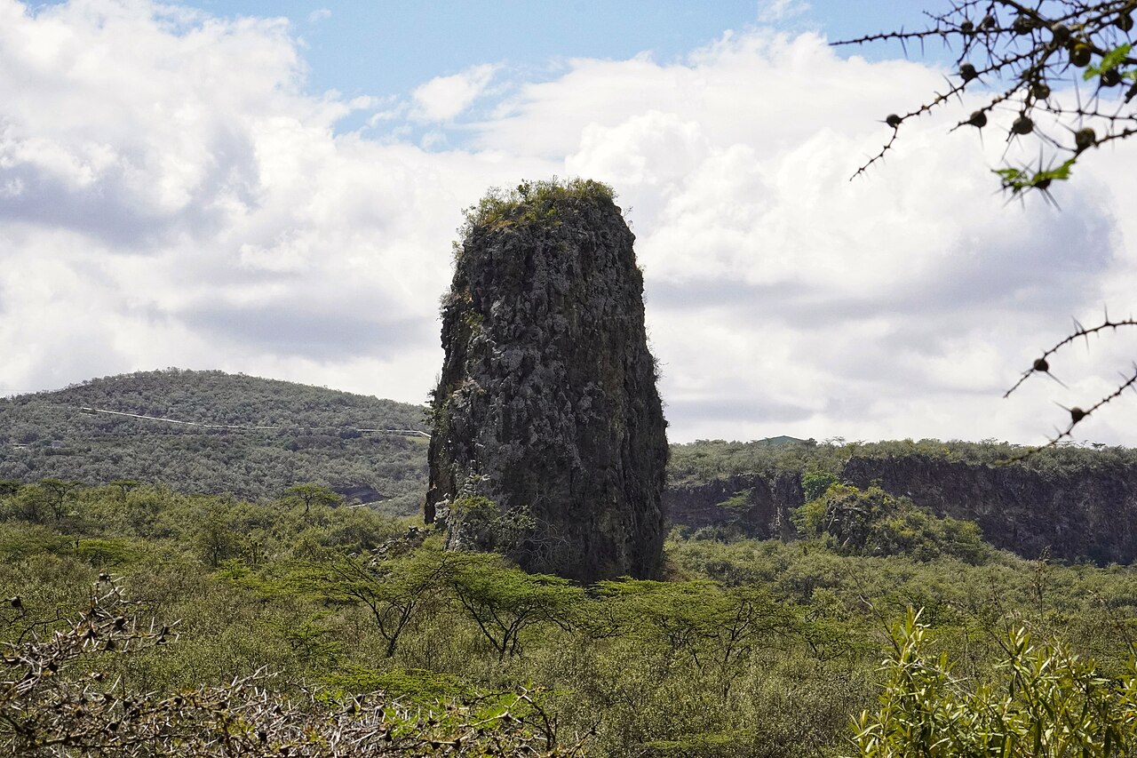
Volcanic tower and woodland in Hell’s Gate National Park. Photo: VinceTraveller · CC BY 2.0. Resized and cropped for this layout.
.jpg)
Hell’s Gate National Park at a glance
Hell’s Gate puts you at ground level in Kenya’s Rift Valley. Zebra graze beneath sheer cliffs, giraffes browse the valley edges and volcanic towers rise above dusty tracks. Cycling and approved walking routes make the experience unusually active for a national park. Choose it for scenery, movement and common plains wildlife; allow a separate safari elsewhere if big cats are your main priority. A night around Lake Naivasha makes an early start much easier than a long return trip from Nairobi.
Official sources · checked 8 September 2026: Kenya Wildlife Service: Hell’s Gate visitor information and live fees · Kenya Wildlife Service: current park notices and contacts. Confirm arrangements for your travel date.
When is the best time to visit Hell’s Gate?
A dry morning is a good starting point for a cycling visit. January–February and much of June–September often give workable conditions, although rain is possible in any month. Early light makes the cliff faces easier to read and leaves time to return before the hottest part of the day. Wind and dust can become tiring on exposed tracks. During the wetter March–May period and the shorter late-year rains, flexible plans are particularly useful. Rain falling upstream can affect narrow drainage channels even when your immediate surroundings look dry. Choose the activity after hearing the day’s briefing: an open main-valley ride and a closed gorge are compatible conditions, not contradictory advice. If cloud obscures distant views, a slower visit focused on rock textures, grazing animals and birds can still be rewarding.
Typical seasonal pattern, not a forecast or a guarantee of road access. Current local conditions take priority.
Which Hell’s Gate area suits your trip?
| Area | Best for | What to expect | Planning point |
|---|---|---|---|
| Elsa Gate and Fischer’s Tower | A first visit and shorter ride | The main-valley approach combines cliffs, grazing ground and an obvious volcanic landmark. | Agree a turnaround point and keep enough energy for the return ride. |
| Central valley and approved circuits | A longer scenic outing | Open ground and changing cliff angles reward unhurried stops. | Ask which tracks allow cycling or walking that day; do not follow every mapped road. |
| Gorge and ranger-post area | A guided landscape interpretation stop | Eroded channels explain a different side of the park’s geology. | Any descent depends on explicit current permission and suitable conditions. |
| Olkaria side | Geothermal landscape and a separately arranged spa visit | Steam and energy infrastructure form part of the wider volcanic setting. | Confirm road access, spa hours and separate charges before adding this to a cycling day. |
| South Lake Naivasha shore | Accommodation and a second day outside the park | Lakeside bases offer a change of habitat and convenient access to the park road. | Lake activities and private sanctuaries have separate bookings and entry conditions. |
Hell’s Gate entry fees, permits and opening hours
The person-entry amounts below are those displayed on the live KWS park page when reviewed. Budget separately for a vehicle or bicycle-related charges, bicycle hire, a guide, climbing equipment and any geothermal spa visit. Check the applicable child age band, citizenship or residency evidence and payment instructions directly with KWS. Compare a tour’s inclusions carefully: “Hell’s Gate excursion” may describe transport alone, while another price includes entry and equipment. Agree the full cost and return arrangement before setting off.
| Visitor category | Adult / listed amount | Child / other detail |
|---|---|---|
| East African citizen | KES 500 | KES 250 |
| Kenya resident | KES 675 | KES 350 |
| Other African citizen | USD 20 | USD 10 |
| Non-resident | USD 50 | USD 25 |
Official sources · checked 8 September 2026: Kenya Wildlife Service: Hell’s Gate visitor information and live fees · KenGen: geothermal visitor context. Confirm arrangements for your travel date.
Opening hours
KWS publishes gate hours of 06:00–18:00. Allow time for entry formalities and return before closing; lodge activities have their own arrangements.
Official sources · checked 8 September 2026: Kenya Wildlife Service: Hell’s Gate visitor information and live fees · Kenya Wildlife Service: current park notices and contacts. Confirm arrangements for your travel date.
How do you get to Hell’s Gate?
The normal first-visit approach is from Naivasha via Moi South Lake Road and the turn toward Elsa Gate. A Nairobi day trip is possible, but a lakeshore overnight gives more flexibility for an early ride and removes the pressure to combine a long road journey with afternoon heat. Arrange transport to the actual gate, not simply to Naivasha town. If hiring bicycles near the entrance, check brakes, tyres, saddle adjustment and how a breakdown will be handled; get a helmet that fits. Keep drinking water accessible rather than buried in a bag. Visitors arriving at a regional airstrip still need a booked road transfer. Roads around the geothermal area and alternative gates should be checked with KWS; a navigation app may choose an operational or unsuitable track.
Official sources · checked 8 September 2026: Kenya Wildlife Service: Hell’s Gate visitor information and live fees · Kenya Wildlife Service: current park notices and contacts. Confirm arrangements for your travel date.
Hell’s Gate safari map: 24 useful places
Use this map to compare bases and understand the landscape. Search by place or filter by type. All locations are approximate orientation points; current park, guide and lodge directions override the map.
Loading map near this section. All places are also listed below.
All 24 map places and access notes
- Elsa Gate · Gates & visitor centresUsual main-valley entrance. Complete entry and obtain the current cycling, walking and gorge briefing here. Map source. Approximate.
- Olkaria Gate · Gates & visitor centresAlternative park access; confirm the appropriate road and opening arrangements for your activity. Map source. Approximate.
- Narasha Gate · Gates & visitor centresSecondary approach. Use only after confirming current KWS directions and access. Map source. Approximate.
- Fischer’s Tower · ViewpointsVolcanic landmark on the main-valley side. Climbing requires a separately arranged provider and permission. Map source. Approximate.
- Central Tower · ViewpointsLandscape reference. Stay on the authorised circuit rather than navigating directly to the rock. Map source. Approximate.
- Kaparatania viewpoint · ViewpointsMapped viewpoint; confirm the permitted approach and current conditions. Map source. Approximate.
- Hobley’s Volcano viewpoint · ViewpointsGeothermal-side landscape reference; road and pedestrian access require current advice. Map source. Approximate.
- Gorge-area ranger post · Gates & visitor centresAsk for the current permitted route. This marker does not establish that gorge descent is open. Map source. Approximate.
- Cliff Base picnic area · ViewpointsMapped designated-stop reference; confirm current use and watch for wildlife. Map source. Approximate.
- Buffalo Circuit picnic area · ViewpointsA circuit orientation point, not permission to cycle every connecting track. Map source. Approximate.
- Maibeni picnic area · ViewpointsConfirm which stopping area is open and follow the ranger briefing. Map source. Approximate.
- Naiburta public campsite · Camps & lodgesKWS-listed camping option. Confirm booking, equipment and facilities. Map source. Approximate.
- Oldubai public campsite · Camps & lodgesAlso mapped as Ol Dubai. Confirm facilities and current camping arrangements. Map source. Approximate.
- Endachata special campsite · Camps & lodgesSpecial-campsite arrangements must be confirmed with KWS in advance. Map source. Approximate.
- Fisherman’s Camp — outside base · Camps & lodgesNaivasha lakeshore base outside the park. Separate accommodation and park entry arrangements. Map source. Approximate.
- Carnelly’s — outside base · Camps & lodgesSouth-lakeshore accommodation reference. Confirm gate transfers and activity inclusions. Map source. Approximate.
- Elsamere — outside base · Camps & lodgesLakeshore accommodation and conservation-history context outside Hell’s Gate. Map source. Approximate.
- Crater Lake camp — separate sanctuary · Camps & lodgesA separate destination; its entry and activities are not covered by Hell’s Gate admission. Map source. Approximate.
- Naivasha Kongoni Lodge — outside base · Camps & lodgesRegional base near the western lakeshore. Confirm the drive to your chosen park gate. Map source. Approximate.
- Oloiden campsite — outside base · Camps & lodgesSeparate lakeshore camping option, with its own bookings and wildlife precautions. Map source. Approximate.
- Lake Oloidien — regional reference · Water featuresWaterbody-centre orientation pin, not a public launch or swimming point. Map source. Approximate.
- Crater Lake — separate sanctuary · Water featuresRegional landscape reference with separate visitor arrangements. Map source. Approximate.
- Naivasha airfield — regional arrival · AirstripsConfirm flight availability and onward road transfer; no scheduled service is implied. Map source. Approximate.
- Oserian airstrip — arranged access · AirstripsPrivate or arranged aviation access requires the responsible operator’s confirmation. Map source. Approximate.
Map references include official park material where specified below, plus OpenStreetMap contributors, checked 8 September 2026. Selected and labelled by See.Africa. Waterbody-centre pins and summits are geographic references, not destinations for direct navigation. Accommodation and airstrip operation must be confirmed. No live animal locations or verified driving route is shown.
A practical Hell’s Gate itinerary
Half day: a relaxed main-valley visit
Arrive early, complete entry and decide between a bicycle and vehicle. Pause around the tower and cliff scenery, then continue only as far as comfortably suits the group. Look for zebra social behaviour and giraffes browsing the valley margins. Leave time for the return and equipment handover.
Full day: add one distinct activity
Build on the main-valley outing with either a properly arranged climb, an authorised guided walk or an Olkaria-side visit. Choose one addition rather than assuming every attraction fits. Confirm where you will eat, refill water and meet transport; shade and services are limited along some routes.
Second day: change habitat at Naivasha
Stay outside the park and arrange a lake or sanctuary activity with its responsible operator. Waterbirds and lakeside woodland complement the dry cliffs. Keep entry fees and safety instructions separate for each place, and leave sufficient time for onward travel.
If weather changes
Replace an exposed ride with a shorter vehicle visit or postpone the active part. A cancelled gorge descent need not become a disappointing day: the main valley’s scale, volcanic forms and ordinary wildlife remain worthwhile subjects when those routes are open.
Where should you stay in Hell’s Gate?
For most visitors, accommodation along the south shore of Lake Naivasha is the practical choice. Compare the drive to Elsa Gate, meal availability and whether bicycle or guide arrangements are actually included. Fisherman’s, Carnelly’s, Elsamere and nearby lodges occupy different positions along the lakeshore; a lakeside photograph does not tell you the final road distance. Inside the park, KWS lists Naiburta and Oldubai public campsites and Endachata special campsite. Ask about booking, toilets, water, cooking arrangements and equipment before choosing camping. A special campsite requires its own arrangements and should not be treated as an unstaffed public picnic stop. Food must be secured at both park and lakeshore camps.
Hell’s Gate mammals to look for
The open valley is an excellent place to learn familiar grazers without treating every stop as a search for a rarer animal. Zebra, giraffe and antelope may be visible from approved routes. Buffalo require plenty of space, particularly for people on foot or bicycles. Hyenas are more elusive; their inclusion is a field reference, not a promise of a daytime encounter. Stay alert even where other visitors seem relaxed.

Plains zebra
Look beyond the stripes: herd spacing, ears and alarm behaviour can tell you what is happening in a grassland. Foals may rest while adults stand watch. Scan the edges of a herd for predators without losing sight of the zebras’ own social interactions.


Masai giraffe
Irregular, jagged patches and long legs mark this East African browser. Giraffes feed selectively in woodland and can remain surprisingly hidden among trees. Watch the tongue and lips selecting leaves, and leave plenty of space when an animal spreads its legs to drink.
_Arusha.jpg)

African buffalo
A heavy, dark bovid with a sweeping horn boss in mature bulls. Herds graze and rest together, while solitary bulls may stay close to cover. Buffalo can be difficult to read at close range: observe from the vehicle or follow your walking guide’s exact instructions.
_male_with_cattle_egret.jpg)

Common eland
Africa’s largest antelope has a deep body, a dewlap and gently spiralling horns. Its size does not prevent it from moving gracefully through open woodland. Watch mixed-age groups at a respectful distance and distinguish it from buffalo by its lighter build and horn shape.


Coke’s hartebeest
The elongated face, sloping back and angular horns are good clues. This form is often called kongoni. Groups use open grassland, where an alert individual may stand apart and scan for danger. Compare its shape with topi or wildebeest instead of relying only on colour.


Common warthog
Facial pads, curved tusks and a tail held upright when running make identification straightforward. Warthogs often kneel on their front legs to feed. Give burrow entrances space, and do not approach a family because the piglets appear small or playful.
,_parque_nacional_del_Lago_Mburo,_Uganda,_2024-02-01,_DD_26.jpg)

Olive baboon
A dog-like muzzle and olive-grey coat identify a social primate frequently seen on roads and forest margins. Troops forage widely and may investigate picnic areas. Keep food inside closed bags and vehicles; feeding or teasing baboons creates problems for later visitors.
,_parque_nacional_del_lago_Nakuru,_Kenia,_2024-05-18,_DD_39.jpg)

Rock hyrax
This small, rounded mammal may sun itself on rocks before retreating into a crevice. Look for sentries and listen for alarm calls. Hyraxes are mammals, despite their superficially rodent-like appearance; rocky picnic areas can offer good observation from an appropriate distance.


Thomson’s gazelle
A small, lightly built gazelle with a dark stripe along the flank and a pale rump. Compare its size and markings with larger antelope rather than relying on a quick glimpse of horns. Watch a group feeding and lifting their heads in turn; the open valley makes this everyday vigilance easier to notice.
,_parque_nacional_de_Amboseli,_Kenia,_2024-05-23,_DD_11.jpg)

Spotted hyena
Sloping shoulders and rounded ears help separate it from other large carnivores. This is an effective hunter as well as a scavenger. Animals travelling at dawn, resting near drainage lines or calling after dark reveal a social life easily missed on a hurried drive.
.jpg)
Hell’s Gate birds and habitat clues
Cliffs, open grass and thorn woodland call for different ways of looking. Scan the sky for raptors, then examine ground birds and low perches during quiet stops. Vultures and eagles can be far away; binoculars are more useful than approaching a cliff base. Nest sites are deliberately omitted from the map. Lake Naivasha’s waterbirds belong to a separate habitat and should not be assumed to occur along a dry park circuit.

Verreaux’s eagle
A large dark eagle associated with rocky landscapes. Adults show a pale back marking and contrasting wing panels, although distance and strong backlight can hide them. Watch the shape and soaring pattern with binoculars. Cliff nesting birds should be observed from public routes without approaching ledges.
,_Aquila_verreauxii,_at_Walter_Sisulu_National_Botanical_Garden,_Gauteng,_South_Africa_(28825027073).jpg)

Rüppell’s vulture
A large soaring vulture with mottled pale markings on the dark body of an adult. Several vulture species can share the same airspace, so a distant silhouette is not enough for a confident identification. Give roosts and breeding cliffs a wide margin and leave any carcass approach to the guide’s judgement.
_Serengeti.jpg)

Augur buzzard
A broad-winged raptor often watched above highland grassland and rocky slopes. Pale adults have strongly contrasting dark upperparts and a reddish tail; darker forms occur too. Compare wing pattern and flight with nearby eagles rather than estimating size against an empty sky.
.jpg)

Secretarybird
A very long-legged raptor that hunts on foot through open grass. Its crest and long tail are useful at distance. Watch a walking bird with binoculars and leave its path clear; following closely can disrupt the search for prey.


Kori bustard
A heavy, long-necked bird that walks slowly across open ground. Its muted plumage blends into dry grass surprisingly well. Scan beyond obvious mammals and give displaying or feeding birds room; a bustard taking flight may have been disturbed.
_male.jpg)

Superb starling
Iridescent blue-green upperparts, a pale eye and rusty belly make this familiar East African starling easy to learn. Camps and woodland edges often provide good views. Natural feeding behaviour makes a better photograph than a bird attracted with human food.
.jpg)

Lilac-breasted roller
Bright lilac underparts and blue wings distinguish this conspicuous perch hunter. Check isolated branches along open woodland roads. Wait for the bird to hunt and return naturally instead of driving closer every time it shifts its position.


Helmeted guineafowl
A spotted dark body and bony helmet identify this noisy ground bird. Parties scratch through grass and woodland litter. Give crossing birds time to move together rather than separating a group with the vehicle.
_Serengeti.jpg)

Little bee-eater
A small green bee-eater with a yellow throat and dark breast band. Pairs use low exposed twigs to launch after insects. Wait at a respectful distance for a return to the perch, avoiding nesting banks and fragile waterside vegetation.
_Namibia.jpg)

White-headed buffalo weaver
The white head and warm orange-red rump distinguish this social dry-country bird. Look around thorn trees and rough twig nests. Watch from the track and avoid approaching active nests, where repeated disturbance can affect breeding birds.
_Serengeti.jpg)
Hell’s Gate plants and habitats
Short-grass grazing ground
The valley’s open patches allow zebra and antelope to feed with a view of their surroundings. Compare short cropped lawns with taller edges; animals respond to the quality of new growth, not simply the amount of green on a map.
Thorn woodland and bush
Vachellia and other woody vegetation supply browse, shade and bird perches. Giraffes can be difficult to notice against a wooded slope despite their height. Stop before passing a promising patch.
Cliff ledges and rock cracks
Vegetation growing in small pockets of soil illustrates how moisture and shelter shape this otherwise exposed environment. View from authorised paths; ledges also provide wildlife refuge.
Drainage channels
Storm runoff reshapes channels and carries water from beyond the visible valley. Fresh erosion and debris are landscape clues, but they cannot establish whether a gorge is safe to enter.
Plant identification may require leaves, flowers, fruit and a knowledgeable guide. Do not collect plants or leave authorised routes to inspect them.
What can you do in Hell’s Gate?
Cycle at a wildlife-watching pace
Treat the ride as a sequence of observation stops, not a race to the gorge. Keep the group together, give animals room to cross and avoid approaching buffalo.
Read the volcanic landscape
Compare the towers, cliff layers and eroded channels. A good local guide can turn dramatic scenery into an explanation of how the valley developed.
Arrange a climb
Fischer’s Tower is associated with rock climbing. Use a qualified provider with suitable equipment and confirm permission, conditions and the actual route in advance. Ordinary entry is not a climbing briefing.
Watch cliff birds
Pause in a permitted open position and scan with binoculars. A soaring bird’s wing shape, tail and flight pattern often reveal more than a distant colour impression.
Rules and practical precautions
Use only routes approved for your activity. Keep clear of cliff edges, geothermal installations and any closed gorge. Do not enter a narrow channel simply because other visitors have done so. Give buffalo and other wildlife space; cycling permission is not permission to approach animals. Follow KWS gate times and speed rules, and carry out all litter.
Give wildlife space
Never feed, surround or block an animal. Keep food secure, voices low and movements predictable. Your guide or ranger’s instructions take priority over a desired photograph.
Prepare for your actual activity
Bring water, sun or rain protection as appropriate, suitable footwear and charged equipment. Tell the operator about relevant mobility needs before booking so the route and vehicle can be matched to you.
Official sources · checked 8 September 2026: Kenya Wildlife Service: Hell’s Gate visitor information and live fees · Kenya Wildlife Service: current park notices and contacts. Confirm arrangements for your travel date.
Hell’s Gate travel FAQ
How long do you need at Hell’s Gate?
Allow half a day for a relaxed main-valley visit, or a full day when adding one separately arranged activity. Staying around Naivasha makes an early start easier.
Can I hire a bicycle at Hell’s Gate?
Bicycle hire is available around the park approach, but confirm the provider, price, condition, helmet and breakdown arrangement before entry. Hire and park fees are separate unless explicitly bundled.
Can visitors walk through the gorge?
Only if KWS confirms that the specific route is open and authorises the activity under current conditions. Never assume gorge access from an old itinerary or photograph.
What are the non-resident entry fees?
The KWS park page displayed USD 50 per adult and USD 25 for the listed child category when checked on 8 September 2026. Confirm current categories and additional activity or vehicle charges before paying.
Are there dangerous animals?
Yes. Buffalo and other wild animals require space even on an approved walking or cycling route. Follow the entry briefing and do not attempt to pass closely through a group.
Is Hell’s Gate a good alternative to the Masai Mara?
It offers a different experience: active exploration and volcanic cliffs near Naivasha. For extensive predator-focused vehicle safaris, give the Mara or another major wildlife park its own stay.
Sources, method and review date
This guide combines official park and operator information with editorial planning advice. Operational details were checked on 8 September 2026. Season descriptions are typical patterns, and suggested stays are planning recommendations. Wildlife profiles explain identification and habitat; they do not promise sightings.
Wildlife and image references
Species names and identification photographs were checked against the linked reference and image records. Photographs are identification examples and may have been taken elsewhere. Each image carries its own creator and licence credit.
Species reference links
Plains zebra · Masai giraffe · African buffalo · Common eland · Coke’s hartebeest · Common warthog · Olive baboon · Rock hyrax · Thomson’s gazelle · Spotted hyena · Verreaux’s eagle · Rüppell’s vulture · Augur buzzard · Secretarybird · Kori bustard · Superb starling · Lilac-breasted roller · Helmeted guineafowl · Little bee-eater · White-headed buffalo weaver